 by
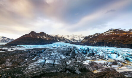
by Earth’s polar regions and glaciers are undergoing dramatic changes due to climate change. From Greenland’s ice sheet to Antarctica’s vast frozen expanse, ice is melting at alarming rates, contributing to rising sea levels and altering global climate systems. Understanding these changes requires not only field observations but also precise, continuous monitoring. This is where satellites come into play.
Satellites have revolutionized the study of ice loss, enabling scientists to measure changes in ice thickness, extent, and mass in near real-time. By combining various types of satellite data, researchers can track trends, predict future scenarios, and inform climate policy.
This article explores how satellites monitor ice loss, the technologies behind the measurements, and the implications of this real-time tracking for science and society.
Why Monitoring Ice Loss Matters
Ice sheets and glaciers are essential regulators of the Earth’s climate. They reflect sunlight, help maintain ocean circulation, and store vast amounts of freshwater. Rapid ice loss has multiple consequences:
- Sea-Level Rise: Melting glaciers contribute significantly to global sea-level rise, threatening coastal communities worldwide.
- Ecosystem Disruption: Many species rely on ice-dependent habitats. Loss of ice affects polar bears, seals, penguins, and migratory birds.
- Climate Feedback Loops: As ice melts, darker surfaces like oceans and land are exposed, absorbing more heat and accelerating warming.
Monitoring ice loss in real-time allows scientists to detect these changes early, improve climate models, and support disaster preparedness for vulnerable regions.
Types of Satellites Used for Ice Monitoring
Different satellites provide complementary data, each offering unique insights into ice dynamics:
1. Optical Satellites
Optical satellites capture images in visible light, similar to regular cameras but from space. They are ideal for observing:
- Ice Extent: Tracking the areal coverage of ice sheets and glaciers.
- Surface Features: Detecting cracks, melt ponds, and snow cover changes.
Limitations: Optical satellites cannot see through clouds or darkness, which can limit data availability in polar regions during winter. Examples include NASA’s Landsat series and the European Space Agency’s Sentinel-2.
2. Radar Satellites
Radar satellites use microwave signals to penetrate clouds and darkness. Synthetic Aperture Radar (SAR) satellites are particularly valuable because they can measure:
- Ice Movement: Tracking glacier flow rates.
- Surface Deformation: Detecting subtle changes in ice elevation.
SAR data are crucial for real-time monitoring because they provide consistent information regardless of weather or light conditions. Key missions include ESA’s Sentinel-1 and Canada’s RADARSAT.
3. Altimetry Satellites
Altimetry satellites measure the height of ice surfaces above sea level using radar or laser pulses. By tracking changes in elevation over time, scientists can calculate ice thickness changes.
- ICESat-2 (NASA): Uses laser altimetry to measure small variations in ice sheet elevation.
- CryoSat-2 (ESA): Uses radar altimetry optimized for polar regions.
These measurements are essential for estimating ice mass loss and understanding which areas of the ice sheet are thinning fastest.
4. Gravimetry Satellites
Gravimetry satellites detect changes in the Earth’s gravitational field caused by shifting ice mass. The most notable mission is GRACE (Gravity Recovery and Climate Experiment) and its successor GRACE-FO.
- When ice melts, water moves from ice sheets into the ocean, slightly altering the local gravitational pull.
- By measuring these changes, scientists can quantify total ice mass loss over large regions.
Gravimetry provides a complementary view to optical and radar data, offering large-scale mass balance assessments rather than just surface observations.
How Real-Time Ice Tracking Works
Real-time ice tracking combines data from multiple satellite types and integrates them into models to detect changes as they happen. The process involves:
1. Data Acquisition
Satellites orbit Earth continuously, sending vast amounts of data back to ground stations. Optical, radar, altimetry, and gravimetry satellites each collect specialized measurements, often several times per day.
2. Data Processing
Raw satellite signals must be corrected for:
- Atmospheric effects
- Satellite motion
- Sensor calibration
Advanced algorithms convert raw data into actionable information, such as ice thickness maps or velocity fields.
3. Integration and Modeling
Data from multiple satellites are combined to create a comprehensive picture of ice conditions. For example:
- SAR provides movement speed.
- Altimetry provides thickness.
- Gravimetry provides mass change.
This integrated dataset allows researchers to track ice loss trends in real-time and forecast future changes.
4. Visualization and Accessibility
Processed data are often made available to scientists and policymakers via platforms like NASA’s Earthdata, ESA’s Copernicus Open Access Hub, and other global monitoring portals. Interactive maps, time-lapse imagery, and predictive models help stakeholders understand current conditions.
Case Study: Greenland Ice Sheet
The Greenland Ice Sheet has lost thousands of gigatons of ice in the past few decades. Satellites have been instrumental in documenting these changes:
- Flow Acceleration: Radar satellites revealed that glaciers such as Jakobshavn Isbræ are moving faster toward the sea.
- Thinning Ice: Altimetry satellites show widespread surface lowering.
- Mass Loss: GRACE data quantify annual ice loss contributing to global sea-level rise.
Real-time monitoring has allowed scientists to issue warnings about potential ice collapse and contributed to more accurate global sea-level projections.
Challenges in Satellite Ice Monitoring
Despite technological advances, monitoring ice from space has challenges:
- Data Gaps: Polar darkness, cloud cover, or satellite outages can cause intermittent coverage.
- Complex Terrain: Mountains and crevassed glaciers can complicate radar and laser measurements.
- Calibration: Gravimetry requires careful calibration to distinguish ice loss from other mass changes like groundwater depletion.
Researchers address these issues by combining data from multiple satellite systems and developing advanced models to fill gaps.
The Future of Ice Monitoring
Next-generation satellites and enhanced computing will improve real-time ice monitoring:
- Higher Resolution Sensors: Finer spatial resolution allows tracking of smaller glaciers and crevasses.
- Artificial Intelligence (AI): Machine learning can detect subtle changes in ice dynamics and predict potential collapse events.
- CubeSats and Microsatellites: Networks of smaller satellites can provide near-continuous monitoring at lower costs.
- Integration with Climate Models: Real-time ice data will increasingly feed into global climate models for better forecasting.
These innovations promise earlier warning systems and more accurate projections of sea-level rise.
Implications for Science and Society
The ability to track ice loss in real-time has far-reaching implications:
- Policy Decisions: Governments can make informed choices about coastal adaptation and mitigation.
- Disaster Preparedness: Monitoring glacier calving or rapid ice sheet changes can reduce risks from flooding or sea-level rise.
- Climate Research: Continuous data improve understanding of the Earth’s climate system and feedback mechanisms.
- Public Awareness: Real-time visualizations help convey the urgency of climate change to a global audience.
Satellites turn distant, inaccessible ice fields into observable systems that anyone—from scientists to policymakers—can understand.
Conclusion
Satellites have transformed our understanding of Earth’s ice. Through optical imagery, radar, altimetry, and gravimetry, scientists can measure ice thickness, movement, and mass loss in near real-time. This information is essential for predicting sea-level rise, understanding climate dynamics, and preparing societies for the impacts of a warming world.
Real-time satellite monitoring has shifted glaciology from a field constrained by remote locations to one with global oversight. By continuously tracking ice loss, satellites not only inform science but also empower humanity to respond to climate change before it’s too late.
The frozen regions of Earth are no longer silent or inaccessible. Through the eyes of satellites, we watch them change, and in doing so, gain the knowledge necessary to protect our planet.