 by
Deep in the remote Pamir Mountains of Tajikistan lies one of the most remarkable natural wonders of Central Asia: Fedchenko Glacier. Stretching across a vast mountain landscape, this enormous river of ice is widely recognised as the longest glacier outside the polar regions. Its impressive length, considerable ice volume and extensive network of tributaries make it one of the most important glaciers in the world.
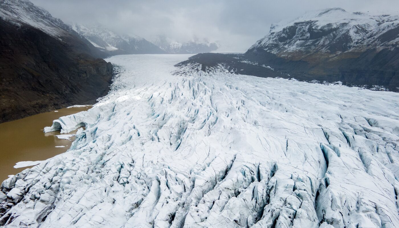
Often described as a frozen river, Fedchenko Glacier flows through high-altitude valleys surrounded by some of the tallest mountains in Central Asia. Its ice originates in elevated snow-accumulation areas and gradually moves towards lower elevations, where melting becomes more significant. Along the way, it receives additional ice from smaller glaciers and creates a complex system of frozen channels.
Beyond its extraordinary size, Fedchenko Glacier plays an important role in the region’s water resources. Meltwater contributes to rivers that eventually join the Amu Darya system, supporting communities and ecosystems across parts of Central Asia. The glacier is also valuable to scientists because its ice contains information about past atmospheric conditions and environmental changes.
Like other mountain glaciers, Fedchenko is affected by rising temperatures and changing precipitation. Understanding its behaviour is essential for studying climate change, freshwater availability and the future of the Pamir Mountains.
1. Where Is Fedchenko Glacier Located?
Fedchenko Glacier is situated in the Pamir Mountains of eastern Tajikistan, within the Gorno-Badakhshan region. The Pamirs are sometimes called the Roof of the World because of their extraordinary elevation, rugged peaks and extensive mountain systems.
The glacier occupies a remote part of the central Pamirs, where high mountain ridges, deep valleys and enormous snowfields create favourable conditions for glacier formation.
The surrounding landscape is dominated by steep mountains, rocky slopes and high-altitude basins. Some peaks in the wider Pamir region rise above 7,000 metres, while the glacier itself extends through a broad range of elevations.
Its remote location makes access difficult. Reaching the surrounding valleys requires careful planning, knowledge of mountain conditions and suitable expedition arrangements. The area is not a conventional tourist destination with easy roads and developed visitor facilities.
Fedchenko is also part of Tajik National Park, a protected mountain landscape recognised as a UNESCO World Heritage property. The park contains exceptional natural features, including glaciers, high peaks, alpine habitats and important geological formations.
2. Why Is Fedchenko Glacier So Famous?
Fedchenko Glacier is best known for its remarkable length. At approximately 77 kilometres, it is widely described as the longest glacier outside the polar regions.
This distinction makes it particularly important in global glaciology. Although enormous ice sheets dominate Antarctica and Greenland, mountain glaciers are generally much smaller. Fedchenko stands out because it forms an exceptionally long, connected ice system within a high mountain environment.
Its importance is not limited to length. The glacier also has:
- A large network of tributary glaciers.
- An extensive accumulation area at high elevations.
- A long valley glacier tongue.
- Considerable ice thickness in some sections.
- A substantial freshwater reserve.
- Scientific records extending back many decades.
Fedchenko is also unusual because its lower section is partly covered by rock debris. This material influences how quickly the underlying ice melts and helps explain why its visible outline has sometimes changed less dramatically than its total ice volume.
The glacier therefore provides an important example of why measuring glacier length alone cannot reveal the full condition of a frozen landscape.
3. How Was Fedchenko Glacier Formed?
Fedchenko Glacier developed through a long process of snowfall accumulation, snow compaction and ice movement.
At high elevations, cold temperatures allow snow to remain on the ground for much of the year. When additional snowfall arrives, older layers become buried and compressed by the weight above them.
Over time, the snow changes into firn, a dense intermediate material between fresh snow and glacier ice. Continued compression removes air spaces and gradually creates solid glacial ice.
As the ice becomes thick enough, gravity causes it to move downhill. The movement may be slow, but it continues over long periods and allows the glacier to travel through mountain valleys.
Fedchenko receives ice from several high-altitude accumulation basins. These areas act as natural collection points where snow builds up and becomes glacier ice.
Smaller tributary glaciers feed into the main trunk, adding ice and creating the branching structure visible in satellite images.
The glacier’s enormous size reflects the combination of favourable elevation, mountain topography, long-term snowfall accumulation and the connection between its different ice basins.
4. Understanding the Glacier’s Size and Physical Features
The scale of Fedchenko Glacier is difficult to appreciate without considering its physical characteristics.
Its commonly quoted length is approximately 77 kilometres, although scientific studies have used different measurements and mapped boundaries. Some research describes the main glacier trunk as roughly 72 kilometres long, while broader measurements include additional connected sections.
Its mapped area also varies according to the survey date and whether tributary glaciers are counted separately or as part of a larger system.
A major scientific study published in the Journal of Glaciology in 2014 estimated the glacier’s total ice volume at approximately 123.4 cubic kilometres, with an uncertainty of about 28 cubic kilometres. The research also examined its area and elevation changes over several decades.
The glacier’s ice thickness varies considerably. Measurements and estimates indicate that some central sections contain several hundred metres of ice, with particularly thick areas approaching or exceeding 800 metres in earlier surveys.
These figures show that Fedchenko is not simply a long strip of frozen water. It is a complex ice body containing an enormous quantity of stored freshwater.
Its lower tongue descends towards approximately 2,900 metres above sea level, while its upper accumulation areas extend to elevations above 5,000 metres.
5. The Tributary System: A Network of Frozen Rivers
One of the most interesting features of Fedchenko Glacier is its extensive tributary system.
A tributary glacier is a smaller glacier that flows into a larger one. Similar to smaller streams joining a major river, these ice bodies contribute additional frozen material to the main glacier.
Fedchenko receives ice from several tributary basins, creating a branching structure across the Pamir landscape.
This arrangement has important consequences for glacier behaviour. Each tributary responds to its own local conditions, including snowfall, elevation, slope and temperature. Some may lose ice more rapidly than others, while certain sections may experience temporary changes in movement.
The tributary system also makes glacier mapping more complicated. Scientists must distinguish the main trunk from neighbouring ice bodies and determine whether connected sections should be measured together.
Understanding these relationships is essential for estimating the glacier’s total area, volume and future changes.
6. The History of Fedchenko Glacier’s Discovery and Exploration
The glacier’s history is closely connected with the exploration of the Pamir Mountains during the nineteenth and twentieth centuries.
Russian explorer Alexei Pavlovich Fedchenko was an important figure in Central Asian exploration. The glacier was named in his honour, although it was identified after his death.
The region’s remote location made early mapping extremely challenging. Explorers had to travel through difficult mountain terrain, where steep slopes, high passes, unpredictable weather and limited supplies created major obstacles.
A significant expedition in 1928 helped establish a more accurate understanding of the glacier’s dimensions. Researchers produced detailed maps using field observations and terrestrial photogrammetry.
This early mapping became especially valuable for later scientific comparisons. Because the glacier had been documented relatively carefully, researchers could examine changes in its outline and elevation over many decades.
Subsequent expeditions and surveys added information about ice movement, thickness, weather conditions and glacier dynamics.
Today, historical records are combined with satellite imagery, digital elevation models and modern measurement techniques to understand how the glacier has changed.
7. How Does Fedchenko Glacier Feed Central Asian Rivers?
Fedchenko Glacier is an important freshwater reserve in a region where water availability can be a major environmental and economic concern.
Its meltwater contributes to the Seldara River system, which eventually feeds into the Muksu River. The Muksu joins the Vakhsh River, which forms part of the larger Amu Darya river system.
The Amu Darya is one of Central Asia’s major rivers. Its water supports agriculture, settlements and ecosystems across a region where many areas experience dry conditions.
The glacier’s contribution is particularly relevant during warmer months, when melting ice can supplement river flow.
However, it is important not to assume that the entire Amu Darya depends on Fedchenko Glacier. The river system receives water from numerous glaciers, snowfields, rainfall and other mountain catchments.
The wider Pamir Mountains function as a natural water tower because their high elevations collect snowfall and store water in snow and ice.
This stored water is gradually released into rivers, helping regulate water availability throughout the year.
Changes in glacier size and melting patterns could therefore influence the timing and amount of water reaching downstream areas.
8. Why Is Fedchenko Glacier Important for Climate Research?
Glaciers preserve information about the atmosphere in which their snow originally formed.
As snowfall accumulates, small amounts of dust, chemical particles, air and other materials become trapped within successive layers. Over time, these layers are compressed into ice, creating a natural environmental archive.
Scientists can drill ice cores to investigate past conditions.
Fedchenko Glacier is particularly valuable because of its high-altitude accumulation areas and substantial ice thickness. Researchers have studied snow and firn cores to investigate changes in atmospheric composition and climate-related signals.
These records can help scientists examine:
- Past temperature conditions.
- Changes in snowfall and precipitation.
- Atmospheric dust levels.
- Variations in chemical elements.
- Long-term environmental patterns.
- Changes in atmospheric circulation.
Ice-core research is especially useful in regions where long-term weather observations are limited.
The Pamirs are located in a climatically complex part of Central Asia, influenced by several atmospheric systems. Studying glacier records can therefore improve understanding of how precipitation and temperature have changed over time.
However, interpreting ice-core records requires care. Scientists must consider snow accumulation rates, wind redistribution, melting and the movement of ice within the glacier.
9. Has Fedchenko Glacier Been Retreating?
Fedchenko Glacier has shown a complicated response to climate change.
Many glaciers across the world have experienced substantial retreat and ice loss. However, earlier studies found that Fedchenko’s mapped area and terminus position changed relatively little during parts of the twentieth century.
A major 2014 study examined changes between 1928 and 2000. It estimated that the main glacier trunk lost approximately 5 cubic kilometres of ice volume, while its mapped area changed by only about 1.4%.
The study estimated a total volume of approximately 123.4 cubic kilometres, with a considerable uncertainty range.
Why did the glacier’s area appear relatively stable despite losing ice?
One important explanation is the thick layer of rock debris covering parts of its lower tongue. This material can insulate the ice from direct solar radiation and reduce melting when it is sufficiently thick.
The glacier’s changing behaviour also reflects precipitation patterns. Increased winter snowfall in parts of the Pamir region has helped some glaciers maintain their mass during certain periods.
However, a relatively stable outline does not mean that the glacier is unaffected by warming. Researchers found significant thinning, particularly in lower sections.
A more recent 2025 study examined elevation changes between 1928 and 2021, providing an updated assessment of the glacier’s long-term development.
In addition, a 2026 regional study of several large High Mountain Asia glaciers, including Fedchenko, identified accelerated mass loss during 2015–2022 compared with 2009–2015.
Together, these studies show why glacier monitoring must consider changes in elevation and volume, not just the position of the glacier’s front.
10. The Role of Rock Debris in Protecting Glacier Ice
One of Fedchenko Glacier’s distinctive features is its debris-covered lower tongue.
Rock fragments fall from surrounding mountain slopes and collect on the glacier surface. Over time, this material creates a layer of stones, gravel and other sediment.
The effect of debris on melting depends largely on its thickness.
A thick debris layer can act as insulation, reducing the amount of heat reaching the ice below. This may slow surface melting and help the glacier maintain its visible outline for longer.
However, thin debris can have the opposite effect. Dark particles may absorb sunlight and increase the temperature of the surface, accelerating melting.
Debris-covered glaciers can also develop unusual surface features. Meltwater may collect in depressions, creating ponds and channels, while exposed ice cliffs can melt more quickly than surrounding debris-covered areas.
This means that the lower part of Fedchenko Glacier does not respond uniformly to changing temperatures.
The presence of rock debris helps explain why the glacier’s length may remain relatively stable even while its surface becomes thinner and its total ice volume declines.
11. How Climate Change Could Affect Fedchenko Glacier
Climate change presents a serious long-term challenge for Fedchenko Glacier.
Rising temperatures can increase ice loss, alter snowfall patterns and change the altitude at which snow accumulation balances melting.
The glacier’s response depends on several interacting factors.
Higher temperatures: Warmer conditions increase melting, especially at lower elevations where temperatures are already closer to or above freezing.
Changing snowfall: If more winter precipitation falls as rain instead of snow, the glacier receives less material to replace lost ice.
Longer melting seasons: Earlier spring warming and later autumn cooling can extend the period during which glacier ice is exposed to melting conditions.
Dust and atmospheric particles: Dust transported from dry areas can darken snow surfaces and reduce their reflectivity, increasing solar energy absorption.
Changes in precipitation: Variations in snowfall can either reduce or temporarily support glacier accumulation, depending on the amount, location and season.
The Pamir region is climatically complex, so Fedchenko may not respond in exactly the same way as glaciers in the European Alps or Himalayas.
Nevertheless, continued warming is expected to place increasing pressure on its long-term ice reserves.
12. Potential Effects on Water Security in Central Asia
The future of Fedchenko Glacier matters because its meltwater contributes to a wider river system used by millions of people.
Glacier retreat can initially increase runoff as additional ice melts. However, this temporary increase cannot continue indefinitely.
Eventually, a glacier may reach a point known as peak water. This is when the contribution from glacier melting reaches its maximum. Afterward, continued ice loss reduces the amount of water available from the glacier.
If this occurs, downstream communities may face changes in seasonal water availability.
Potential consequences include:
- Greater pressure on irrigation systems.
- Changes in river flow during summer.
- Difficulties managing water reservoirs.
- Increased competition between different water users.
- Challenges for agriculture and rural livelihoods.
The exact impact will depend on rainfall, seasonal snow, reservoir management and the contributions of other glaciers.
Fedchenko is only one part of Central Asia’s wider water system, but its large size makes it an important component of the region’s natural freshwater storage.
13. Glacial Lakes and Possible Natural Hazards
As glaciers retreat and thin, water can accumulate in depressions on or around the ice. These bodies of water are known as glacial lakes.
Some develop along glacier margins, while others form on the glacier surface or behind natural barriers made of ice and sediment.
Glacial lakes are natural features, but they can become dangerous if their barriers fail.
A sudden release of stored water is known as a glacial lake outburst flood. Such an event can send large quantities of water, sediment and debris into valleys below.
Possible triggers include:
- Failure of an ice or sediment barrier.
- Ice or rock falling into a lake and displacing water.
- Rapid changes in the lake’s drainage system.
- Heavy rainfall or sudden meltwater input.
Not every glacial lake is dangerous, and the presence of a lake does not automatically indicate that an outburst will occur.
However, monitoring is important in mountainous regions where settlements, roads and infrastructure may lie downstream.
Fedchenko’s changing ice margins and surrounding terrain make long-term observation valuable for understanding possible environmental risks.
14. How Scientists Monitor Fedchenko Glacier Today
Modern technology has greatly improved the ability to study glaciers in remote mountain regions.
Earlier researchers depended heavily on field expeditions, ground surveys and aerial photography. These methods remain important, but they can be difficult and expensive in areas such as the central Pamirs.
Today, scientists use several complementary approaches.
Satellite imagery: Satellites provide repeated images that help researchers map glacier boundaries, observe surface conditions and identify changes over time.
Digital elevation models: These models represent the height of the glacier surface. Comparing models from different years allows researchers to estimate thinning and changes in ice volume.
Radar measurements: Radar instruments can collect information about glacier surfaces and, under suitable conditions, help investigate ice thickness and movement.
GPS surveys: Ground-based positioning systems allow scientists to measure the movement of selected points on the glacier.
Ice-core sampling: Drilling into snow and ice helps researchers investigate historical environmental conditions.
Weather monitoring: Temperature, precipitation and other atmospheric measurements help explain why glacier mass changes from year to year.
Combining these techniques produces a more complete picture than relying on any single method.
15. Is Fedchenko Glacier Suitable for Tourism?
Fedchenko Glacier is an extraordinary natural attraction, but it is not an easy destination for ordinary sightseeing.
Its remote location, high altitude and difficult terrain make travel challenging. Visitors may need to cross rough mountain routes, arrange specialist transport and work with experienced local guides.
High-altitude conditions can also create health and safety concerns. Cold temperatures, sudden weather changes, limited facilities and the risk of altitude sickness require careful preparation.
Unlike more accessible glaciers in Europe, Fedchenko does not have a conventional visitor infrastructure with easy roads, viewing platforms and regular tourist services.
Anyone considering an expedition should arrange the journey through reputable local specialists and check current access requirements, permits, weather and safety conditions.
Visitors should also respect the protected natural environment. Removing material, leaving litter or disturbing fragile habitats can damage a landscape that has scientific and ecological value.
For many people, satellite imagery and scientific photographs offer the most practical way to appreciate the glacier’s immense scale.
16. What Does the Future Hold for Fedchenko Glacier?
The future of Fedchenko Glacier will depend on changes in global temperature, regional precipitation and the glacier’s own physical characteristics.
Its enormous size means that it will not respond in exactly the same way as a small mountain glacier. Large ice bodies can take considerable time to adjust to changing climatic conditions.
Its high-altitude accumulation basins may continue receiving snowfall, while the debris-covered lower tongue may experience slower surface melting in some areas.
However, these characteristics do not make the glacier immune to climate change.
Continued warming could cause greater thinning, reduce ice volume and eventually affect the amount of meltwater entering nearby rivers.
Scientists will need long-term measurements to understand how quickly these changes occur. Continued satellite monitoring, field research and improved climate models will be essential.
Protecting the glacier also requires broader climate action. Reducing greenhouse gas emissions can help limit future warming, while better water management can help communities prepare for changing river flows.
Conclusion
Fedchenko Glacier is one of the most extraordinary mountain glaciers on Earth. Located in Tajikistan’s remote Pamir Mountains, it stretches for approximately 77 kilometres and is widely recognised as the longest glacier outside the polar regions.
Its immense size, branching tributary system and substantial freshwater reserves make it important for both the natural environment and the people of Central Asia. Its meltwater contributes to rivers within the Amu Darya system, while its ice preserves valuable information about historical atmospheric conditions.
Scientific research has revealed that Fedchenko’s behaviour is more complicated than a simple story of rapid retreat. Its debris-covered lower tongue, changing snowfall patterns and high-altitude accumulation areas influence how it responds to warming. Although some earlier measurements showed relatively small changes in area, the glacier has experienced significant ice-volume loss and thinning.
The future of this frozen giant will depend on climate conditions and the choices made to reduce global warming. Continued monitoring and responsible water management will be essential for understanding and responding to its changes.
Fedchenko Glacier is more than a record-breaking natural feature. It is a valuable part of Central Asia’s environmental heritage, a freshwater resource and a natural archive of Earth’s changing climate.